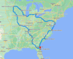


Michigan Drive Times: How Far Is Everything From You? [Interactive Map]
Planning a road trip around Michigan? Whether you’re flying into Detroit and wondering how far Sleeping Bear Dunes is, or you live in Grand Rapids and want to know if Tahquamenon Falls is a weekend trip or a serious commitment — we built a map for that.
Click any city, airport, or destination on the map below and instantly see drive times to everywhere else in Michigan. No math. No Googling 12 different routes. Just click and go.
Drive times across
Michigan
to see drive times
from that location
How to Use This Map
It’s simple — click any dot and the panel on the right updates instantly with drive times to every other location, sorted from closest to farthest. Here’s what the dots mean:
- Sky blue dots with rings — Airports (DTW, GRR, TVC)
- Blue dots — Cities
- Gold dots — Destinations (parks, dunes, waterfalls, bridges)
The lines on the map are colored by drive time — green for close, yellow for medium, orange and red for far, purple for the serious UP adventures.
What’s on the Map
We included 20 locations across Michigan — a mix of major airports, cities, and the destinations people actually road trip to:
- Airports: Detroit Metro (DTW), Gerald R. Ford/Grand Rapids (GRR), Cherry Capital/Traverse City (TVC)
- Cities: Ann Arbor, Flint, Lansing, Port Huron, Saginaw, Kalamazoo, Holland, Tawas City, Alpena
- Destinations: Traverse City, Petoskey, Sleeping Bear Dunes, Silver Lake Sand Dunes, Mackinac Bridge, Tahquamenon Falls, Marquette, Copper Harbor
All drive times are rounded up to the next 5 minutes and reflect direct routes with no traffic. Real world times will vary — Michigan road construction is a season unto itself. 😄
Quick Highlights
- Closest airport to Sleeping Bear Dunes: TVC at just 46 minutes — fly in and you’re basically there
- DTW to Copper Harbor: 9 hours 45 minutes — that’s a commitment, not a day trip
- Grand Rapids to Mackinac Bridge: 3 hours 35 minutes — totally doable for a long weekend
- Petoskey to Mackinac Bridge: Only 48 minutes — if you’re already up north, the bridge is basically next door
- Traverse City to Sleeping Bear Dunes: 40 minutes — the most famous thing in northern Michigan is practically in your backyard if you’re staying in TC
Why We Included Airports
A lot of Michigan visitors don’t start their trip from a Michigan city — they fly in. If you’re landing at DTW and renting a car, the first thing you want to know is how long it takes to get where you’re going. Same goes for GRR and TVC. We included all three major airports as starting points so visitors can plan from the moment they land.
If you’re flying into Detroit and heading to Sleeping Bear Dunes, you’re looking at 4 hours 22 minutes. If you can fly into Traverse City instead, that same trip is 46 minutes. Sometimes the airport you choose changes the whole trip.
Plan Your Michigan Road Trip
Now that you know how long it takes to get there, here’s everything else you need to plan your Michigan road trip:
- How much will gas cost? Check our interactive Michigan gas cost map — every state from Michigan with real route data and each state’s own gas price.
- Looking for Michigan travel deals? We rounded up the best free and discounted programs for Michigan travelers.
- Want to know what’s actually worth stopping for in Michigan? We’ve been building a directory of local attractions, hidden gems, and roadside finds across the state.
Frequently Asked Questions
Why are times rounded up instead of exact?
We always round up to the next 5 minutes because no one has ever arrived somewhere earlier than Google Maps said they would. Rounding up sets realistic expectations and protects you from cutting your timing too close.
Do these times include traffic?
No — all times are based on direct routes with no traffic. Michigan summers can add significant time to routes near popular destinations like Sleeping Bear Dunes and Mackinac Island on weekends. Build in buffer time if you’re traveling in peak season.
Why isn’t my city on the map?
We focused on major airports, population centers, and the destinations Michigan road trippers most commonly target. If your city isn’t on the map, use the nearest listed city as your reference point — drive times will be close enough for planning purposes.
What’s the furthest drive on the map?
DTW to Copper Harbor clocks in at 9 hours 45 minutes and 607 miles — that’s the longest route on the map. Copper Harbor sits at the very tip of the Keweenaw Peninsula in the Upper Peninsula, making it one of the most remote destinations in the entire state. Worth every mile though.
What About Mackinac Island?
You might notice Mackinac Island isn’t on the map — and there’s a good reason for that. You can’t drive to Mackinac Island. At all. Ever. It’s one of the only places in the US that bans cars entirely — horses, bikes, and your own two feet are the only options once you’re there.
To get to the island you take a ferry from either Mackinaw City or St. Ignace — both are right at the Mackinac Bridge. So the real question is how far is the drive to the bridge:
- Detroit to Mackinac Bridge: 4 hours
- Grand Rapids to Mackinac Bridge: 3 hours 35 minutes
- Petoskey to Mackinac Bridge: 48 minutes
Then it’s a short ferry ride and you’re there. No car needed — or wanted! 🚢
A Note on the Upper Peninsula
If you haven’t been to the UP, the drive times might be a wake up call. Marquette is 6 hours 49 minutes from Detroit. Tahquamenon Falls is 5 hours 28 minutes. Copper Harbor is nearly 10 hours. The UP is spectacular but it requires serious planning — it’s not a casual detour.
The good news? Once you cross the Mackinac Bridge everything slows down in the best possible way. The UP rewards the drive. Plan for a long weekend at minimum and you won’t regret it.