


How Much Does Gas Cost to Drive From Maine to Anywhere?
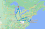
Maine to anywhere
20 MPG vehicle · AAA May 2026 · One way · Hover any state
Total: ~4,458 miles · ~80 hours · Passport required · Route goes entirely through Canada (Quebec, Ontario, Manitoba, Saskatchewan, Alberta, British Columbia, Yukon) · Estimated gas cost ~$1,195 one way
Real Gas Costs From Maine, State by State
Planning a road trip from Maine and wondering how much gas will cost? Or maybe you’re driving up to Maine and want to know what your trip is going to actually cost? Either way, before you load up the car and hit the road, you probably want to know one thing: how much is this actually going to cost in gas?
We built an interactive map that answers that question for every single state — at a glance. It works in both directions: hover any state on the map to see the cost from Maine, or scroll the data table to find your starting state if you’re driving up.
Unlike most gas calculators that spit out one number based on a single national average, this map uses each state’s actual current gas price for the miles you drive through it. That means the cost you see for California uses California’s expensive gas, and the cost for New Hampshire uses New Hampshire’s cheaper gas. The result is a more accurate, more honest look at what your trip will actually cost.
Hover over any state to see the total miles, drive time, gas cost, and a full route breakdown showing every state — and Canadian province — you pass through and what gas costs there.
Gas Cost To Drive From Maine
A few things worth knowing before you read the numbers:
- Vehicle: 20 MPG — a reasonable average for most cars, SUVs, and minivans
- Routes: Actual driving routes from Guilford, Maine — not straight-line distance
- Starting point: Guilford, ME, the geographic center of Maine — about as fair a launch point as you can get. If you’re starting from Portland or Bangor, just add or subtract a few hours for the drive in or out of state.
- Destination: Geographic center city of each state
- Gas prices: Each state’s own AAA average — not a national average
- Data source: AAA Gas Prices, May 2026
- Direction: One way from Guilford, Maine
- Heads up about Maine gas: Maine’s own gas runs $4.52/gallon as of May 2026 — slightly above the national average. The cost to leave Maine adds up faster than you might think because you’re starting with expensive fuel.
This means if you’re driving to Tennessee, we used Tennessee’s gas price for the miles you’re in Tennessee — not Maine’s price for the whole trip. That’s what makes this different from a standard calculator.
Quick Highlights
- Closest and cheapest: New Hampshire at just $46 one way — three hours from Guilford. Practically a tank of gas to get to a different state.
- Most expensive (lower 48): California at $804 — and you literally need a passport to get there from Maine. More on that in a minute.
- The Canada Wrinkle: Four lower-48 destinations require a passport because Google Maps routes them through Canada — Michigan, Wisconsin, Colorado, and California. This is unique to Maine drivers because of how Maine pokes into the northeast corner of the country.
- Plot twist of the year: Driving to Oregon ($787) is actually CHEAPER than driving to California ($804) — even though Oregon is FARTHER (3,377 vs 3,251 miles). The California route runs through expensive Canadian gas before ending at California’s $6.15/gallon. The Oregon route stays in the US the whole way.
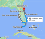
- The Snowbird Run: Maine to Orlando is $330 in gas, 22 and a half hours of driving — the classic I-95 winter migration that real Mainers do every year.
- The New England Neighborhood: All five New England neighbors (New Hampshire, Vermont, Massachusetts, Rhode Island, Connecticut) come in under $80 one way. Maine drivers have the best weekend-getaway map in the country if you don’t mind staying regional.
How Long Does It Actually Take?
Gas cost is only half the equation. Before you commit to a road trip, you also need to know how many hours you’re actually going to be sitting in that car. We mapped that too.
Maine to anywhere
AAA May 2026 · One way · Hover any state
Click any column header to sort · 🛂 = passport required
| State ↕ | Gas Cost ↕ | Drive Time ↕ | Miles ↕ | Gas Price There ↕ |
|---|---|---|---|---|
| New Hampshire | $46 | 3h 5m | 204 mi | $4.49 |
| Vermont | $52 | 4h 47m | 229 mi | $4.56 |
| Massachusetts | $61 | 4h 11m | 270 mi | $4.50 |
| Rhode Island | $69 | 5h 9m | 307 mi | $4.49 |
| Connecticut | $77 | 5h 6m | 339 mi | $4.64 |
| New York | $105 | 7h 26m | 465 mi | $4.61 |
| New Jersey | $116 | 8h 20m | 513 mi | $4.50 |
| Delaware | $138 | 9h 30m | 610 mi | $4.33 |
| Pennsylvania | $140 | 9h 42m | 616 mi | $4.64 |
| Maryland | $151 | 10h 16m | 669 mi | $4.46 |
| Virginia | $192 | 13h 18m | 856 mi | $4.31 |
| West Virginia | $207 | 14h 39m | 912 mi | $4.50 |
| Ohio | $215 | 14h 27m | 939 mi | $4.62 |
| North Carolina | $222 | 15h 40m | 999 mi | $4.17 |
| Michigan 🛂 | $237 | 15h 17m | 1,005 mi | $4.80 |
| South Carolina | $251 | 18h 5m | 1,140 mi | $4.15 |
| Indiana | $267 | 17h 26m | 1,174 mi | $4.10 |
| Kentucky | $272 | 18h 31m | 1,213 mi | $4.17 |
| Georgia | $291 | 20h 27m | 1,337 mi | $4.00 |
| Tennessee | $294 | 20h 18m | 1,331 mi | $4.17 |
| Illinois | $301 | 19h 47m | 1,319 mi | $5.05 |
| Wisconsin 🛂 | $312 | 21h 52m | 1,218 mi | $4.50 |
| Alabama | $320 | 21h 38m | 1,456 mi | $4.09 |
| Florida | $330 | 22h 37m | 1,512 mi | $4.43 |
| Mississippi | $350 | 25h | 1,606 mi | $4.00 |
| Iowa | $355 | 22h 56m | 1,563 mi | $4.29 |
| Missouri | $367 | 25h | 1,621 mi | $4.17 |
| Arkansas | $374 | 26h | 1,718 mi | $4.06 |
| Louisiana | $394 | 28h | 1,823 mi | $4.03 |
| Minnesota | $394 | 26h | 1,738 mi | $4.40 |
| Kansas | $410 | 27h | 1,830 mi | $4.11 |
| Oklahoma | $419 | 28h | 1,871 mi | $4.05 |
| Nebraska | $420 | 28h | 1,867 mi | $4.22 |
| North Dakota | $450 | 30h | 1,998 mi | $4.21 |
| South Dakota | $454 | 29h | 2,016 mi | $4.32 |
| Texas | $459 | 34h | 2,068 mi | $3.99 |
| Colorado 🛂 | $524 | 33h | 2,191 mi | $4.75 |
| New Mexico | $537 | 36h | 2,436 mi | $4.48 |
| Montana | $557 | 37h | 2,482 mi | $4.59 |
| Wyoming | $565 | 38h | 2,524 mi | $4.54 |
| Utah | $602 | 40h | 2,650 mi | $4.68 |
| Arizona | $632 | 42h | 2,844 mi | $4.83 |
| Idaho | $649 | 43h | 2,879 mi | $4.68 |
| Nevada | $702 | 46h | 3,075 mi | $5.25 |
| Washington | $728 | 47h | 3,174 mi | $5.79 |
| Oregon | $787 | 50h | 3,377 mi | $5.34 |
| California 🛂 | $804 | 48h | 3,251 mi | $6.15 |
| Alaska ⚠️ 🛂 | ~$1,195 | ~80h | 4,458 mi | varies* |
Total: ~4,458 miles · ~80 hours · Passport required · Entire route through Canada (7 provinces/territories) · Estimated gas cost ~$1,195 one way
Times are no traffic, direct route, rounded to the nearest 5 minutes. Real world drive time will vary — budget extra for stops, construction, and the inevitable “we need snacks” moment 40 miles before the exit. 😄
Plan Your Trip at a Glance — Gas Cost & Drive Time from Guilford, ME
Sorted by cost, lowest to highest. All prices one way.
| State | Gas Cost | Drive Time | Miles | Gas Price There | Passport? |
|---|---|---|---|---|---|
| New Hampshire | $46 | 3h 5m | 204 | $4.49 | |
| Vermont | $52 | 4h 47m | 229 | $4.56 | |
| Massachusetts | $61 | 4h 11m | 270 | $4.50 | |
| Rhode Island | $69 | 5h 9m | 307 | $4.49 | |
| Connecticut | $77 | 5h 6m | 339 | $4.64 | |
| New York | $105 | 7h 26m | 465 | $4.61 | |
| New Jersey | $116 | 8h 20m | 513 | $4.51 | |
| Delaware | $138 | 9h 30m | 610 | $4.34 | |
| Pennsylvania | $140 | 9h 42m | 616 | $4.64 | |
| Maryland | $151 | 10h 16m | 669 | $4.46 | |
| Virginia | $192 | 13h 18m | 856 | $4.31 | |
| West Virginia | $207 | 14h 39m | 912 | $4.50 | |
| Ohio | $215 | 14h 27m | 939 | $4.62 | |
| North Carolina | $222 | 15h 40m | 999 | $4.17 | |
| Michigan | $237 | 15h 17m | 1,005 | $4.80 | 🛂 |
| South Carolina | $251 | 18h 5m | 1,140 | $4.15 | |
| Indiana | $267 | 17h 26m | 1,174 | $4.10 | |
| Kentucky | $272 | 18h 31m | 1,213 | $4.17 | |
| Tennessee | $294 | 20h 18m | 1,331 | $4.17 | |
| Georgia | $291 | 20h 27m | 1,337 | $4.00 | |
| Illinois | $301 | 19h 47m | 1,319 | $5.05 | |
| Wisconsin | $312 | 21h 52m | 1,218 | $4.50 | 🛂 |
| Alabama | $320 | 21h 38m | 1,456 | $4.09 | |
| Florida | $330 | 22h 37m | 1,512 | $4.43 | |
| Iowa | $355 | 22h 56m | 1,563 | $4.29 | |
| Mississippi | $350 | 25h | 1,606 | $4.00 | |
| Missouri | $367 | 25h | 1,621 | $4.18 | |
| Arkansas | $374 | 26h | 1,718 | $4.06 | |
| Minnesota | $394 | 26h | 1,738 | $4.40 | |
| Louisiana | $394 | 28h | 1,823 | $4.03 | |
| Kansas | $410 | 27h | 1,830 | $4.11 | |
| Nebraska | $420 | 28h | 1,867 | $4.22 | |
| Oklahoma | $419 | 28h | 1,871 | $4.05 | |
| North Dakota | $450 | 30h | 1,998 | $4.21 | |
| South Dakota | $454 | 29h | 2,016 | $4.32 | |
| Texas | $459 | 34h | 2,068 | $3.99 | |
| Colorado | $524 | 33h | 2,191 | $4.76 | 🛂 |
| New Mexico | $537 | 36h | 2,436 | $4.48 | |
| Montana | $557 | 37h | 2,482 | $4.59 | |
| Wyoming | $565 | 38h | 2,524 | $4.54 | |
| Utah | $602 | 40h | 2,650 | $4.68 | |
| Arizona | $632 | 42h | 2,844 | $4.83 | |
| Idaho | $649 | 43h | 2,879 | $4.68 | |
| Nevada | $702 | 46h | 3,075 | $5.25 | |
| Washington | $728 | 47h | 3,174 | $5.79 | |
| Oregon | $787 | 50h | 3,377 | $5.34 | |
| California | $804 | 48h | 3,251 | $6.15 | 🛂 |
| Alaska ⚠️ | ~$1,195 | ~80h | 4,458 | varies* | 🛂 |
Wait, Why Do I Need a Passport to Drive to California?
Because of where Maine sits on the map.
Maine is tucked into the very northeast corner of the United States. Once you head west from Guilford, you’ve got two options: drive all the way south through New Hampshire, Massachusetts, and New York before you can turn west (long), or cut straight up through Quebec and across Ontario to get back into the US near Michigan (shorter and faster).
For four specific destinations — Michigan, Wisconsin, Colorado, and California — Google Maps decides the Canada route is the faster one. So if you punch any of those into Maps from Guilford, ME, you’ll see a route that crosses into Quebec, runs across Ontario, and eventually crosses back into the US.
What this actually means for you:
- Passport required (or an Enhanced Driver’s License — Maine issues them through the BMV)
- Different gas prices — Canadian provinces are generally more expensive than US averages. Quebec runs about $5.48 per US gallon equivalent, Ontario about $5.20
- Border crossing time — typically 5-30 minutes each way, sometimes longer
- Cell service — your US phone plan may rack up roaming charges in Canada unless you have a Canada-included plan, so check before you go
The upside: it’s a beautiful drive, especially in fall. Quebec’s Eastern Townships and the north shore of Lake Superior are scenic in a way I-90 through Indiana absolutely is not.
If you’d rather stay in the US for any of these four destinations, you can manually re-route in Google Maps and force a non-Canada path. It’ll add hours of drive time, but you won’t need the passport.
Alaska: The Special Case
Yes, you can actually drive from Maine to Alaska. But let’s be real — this is a completely different kind of trip.
- Total miles: approximately 4,458 one way
- Drive time: roughly 80 hours
- Passport required: you drive through 3 Canadian provinces and 1 territory — there are no US states between Maine and Alaska
- Route: Maine → Quebec → Ontario → Manitoba → Saskatchewan → Alberta → British Columbia → Yukon → Alaska
- Estimated gas cost: approximately $1,195 one way
For Maine, the Alaska route is entirely a Canadian highway adventure — no other US states to break it up. From Guilford, you cross into Quebec almost immediately, pass north of Montreal, drive across Ontario for hundreds of miles, then up through the prairie provinces (Manitoba and Saskatchewan), through Alberta, into BC, and finally the Yukon before crossing back into the US at Alaska.
Maine to Alaska is the longest Alaska road trip from any state in the lower 48 — longer than Texas to Alaska (4,006 miles) or even Florida to Alaska (4,765 miles becomes 4,458 from Maine because Maine has a more direct Canadian path). Anywhere you start, it’s a lot of road.
Worth knowing: Maine issues Enhanced Driver’s Licenses that allow land border crossings into Canada without a full passport. Check with the BMV before you go.
Frequently Asked Questions
Gas prices are based on AAA state averages from May 2026. Gas prices change constantly — for the most current numbers before your trip, check aaa.com/gas.
It’s a solid average for a typical car, SUV, or minivan on the highway. If you drive a truck you might be closer to 15 MPG; if you drive a smaller sedan you might hit 30 MPG. To calculate your own cost: take the miles shown for your destination, divide by your actual MPG, and multiply by the destination state’s gas price shown in the table.
No — all numbers are one way. Double it for a rough round trip estimate, though your return cost may vary a little depending on gas prices when you travel.
Using the geographic center of each state gives everyone a fair, consistent target. If we picked major cities, some states would look artificially cheap or expensive just because their biggest city happens to be near a border. The center point puts every state on equal footing.
For drivers leaving from Maine, yes — Google Maps routes through Ontario for Michigan, and through Quebec plus Ontario for Wisconsin, Colorado, and California. You can manually force a US-only route in Maps if you don’t have a passport, but it’ll add hours of drive time. See the passport section above for the full details.
Yes! The mileage and drive time are the same in both directions, and the gas cost is close enough to be useful since the same states are in the route either way. If you’re looking at the cost to drive to Maine from, say, Pennsylvania, find Pennsylvania in the table — that $140 number works for both directions, give or take a few dollars depending on where you fill up. Maine itself runs about $4.52 per gallon if you’re filling up here.
Guilford is the geographic center of Maine — using one fixed launch point keeps every state’s number fair and apples-to-apples. If you’re starting from Portland, Bangor, or Augusta, just add or subtract a few hours and a few gallons for the drive to or from Guilford. You can ballpark it pretty easily from the table.
Because gas actually costs different amounts in different states. California regularly runs over $6 a gallon, with Washington and Oregon close behind. Mississippi, Texas, and Georgia often sit closer to $4. If we used Maine’s price for the entire trip, you’d get a completely wrong number for anything south of Virginia or west of New York. We use the actual price in each state for the miles you drive there.
Ready to start planning?
Now that you know what gas will cost, you can stop wondering and start planning. Bookmark this map for next time — and if it saved you some math, share it with the friend who keeps threatening to “just drive to Florida this winter” but won’t commit until they know the number.