

Yes, it snows in California, but only in the mountains. Lake Tahoe, Donner Pass, Mount Shasta, Sequoia, and Big Bear get feet of snow every winter. Los Angeles, San Francisco, San Diego, Sacramento, and Palm Springs get none in a normal year. In California, snow comes down to how high up you are.
Alice’s Pick
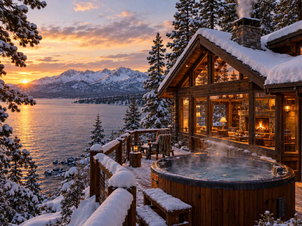
California has snow. And cabins. ❄️
Who says a California vacation has to be beaches and palm trees? Picture a cozy cabin, snow outside, and nowhere you need to be.
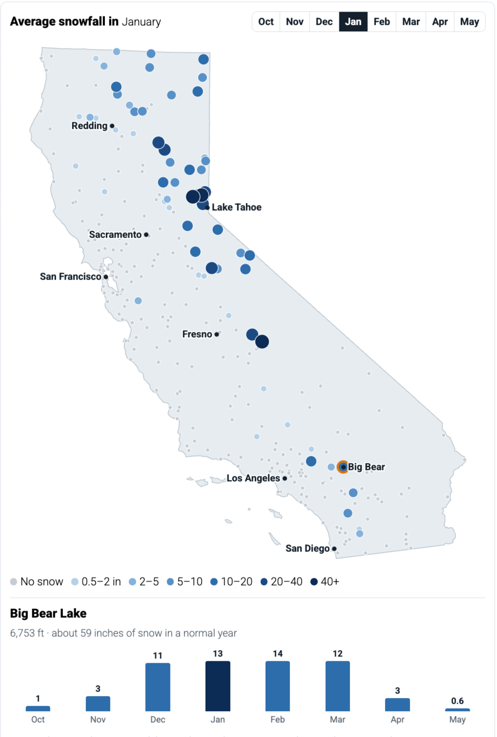
Pick a month and tap any dot on the map. You’ll see how much snow that spot gets in a normal winter. Every number comes from NOAA’s 30-year weather station averages (1991 to 2020).
Average snowfall in January
Tap any dot to see that spot month by month. Gray dots got no snow that month. NOAA weather station averages, 1991–2020; not a forecast. See every winter trouble road on the full map
Where does it snow in California?
Almost all of California’s snow falls above about 3,500 feet. Below that, a snowy winter means a dusting at most. Here’s where the snow really piles up:
- Lake Tahoe and Donner Pass: the snowiest part of the state. Soda Springs, near Donner Summit, averages about 445 inches a year. That’s over 37 feet. Truckee gets about 207 inches and Tahoe City about 179.
- Sequoia and Kings Canyon: Lodgepole averages about 220 inches. Grant Grove gets about 186.
- Far Northern California: Mount Shasta gets about 89 inches. Chester, near Lassen, gets about 110.
- Eastern Sierra: Bodie ghost town gets about 94 inches. Lee Vining, near Yosemite’s east gate, gets about 70.
- Yosemite: Hetch Hetchy gets about 51 inches. The high country gets far more, but Tioga Road closes for the whole winter.
- Southern California mountains: Wrightwood gets about 62 inches, Big Bear Lake about 59, Idyllwild about 31, and Lake Arrowhead about 22.
Does it snow in Los Angeles, San Francisco, or San Diego?
No. California’s big cities don’t get snow in a normal year. They sit near sea level, and the ocean keeps them too warm.
- San Francisco, Sacramento, Fresno, and Palm Springs: NOAA’s 30-year average is zero.
- Bakersfield: about a tenth of an inch a year. Blink and you’ll miss it.
- Redding: about 2.6 inches a year, the most of any Central Valley city, and usually in January.
- Los Angeles and San Diego: no snow in town. But you can see it from LA on a clear day after a storm, sitting on the San Gabriel Mountains.
The closest real snow to Los Angeles is in Wrightwood and Big Bear. San Diego’s closest snow is up in Julian, which averages about 6 inches a year.
When does it snow in California?
California’s snow season runs from about November to April. December through March is when the big storms hit.
- Lake Tahoe and Donner Pass: snow from October into May. At Soda Springs, March is the snowiest month, with about 106 inches.
- Truckee and Tahoe City: February is the snowiest month, with about 41 to 48 inches.
- Mount Shasta: December is the snowiest month, with about 26 inches.
- Big Bear Lake: December through March each average 11 to 14 inches. February is the top month.
- Wrightwood: February brings about 25 inches, most of its year.
If you want snow for a December trip, the Sierra and Mount Shasta are your best bets. For Southern California snow, plan on January to March.
How much snow does California get?
It depends on where you stand. Here’s how a normal year looks across the state, from the snowiest spot down to the cities.
| Place | Elevation | Snow in a normal year | Snowiest month |
|---|---|---|---|
| Soda Springs (Donner Summit) | 6,887 ft | about 445 inches | March |
| Lodgepole (Sequoia) | 6,735 ft | about 220 inches | February |
| Truckee | 5,823 ft | about 207 inches | February |
| Tahoe City | 6,230 ft | about 179 inches | February |
| Mount Shasta | 3,613 ft | about 89 inches | December |
| Wrightwood | 6,000 ft | about 62 inches | February |
| Big Bear Lake | 6,753 ft | about 59 inches | February |
| Hetch Hetchy (Yosemite) | 3,870 ft | about 51 inches | February |
| Idyllwild | 5,380 ft | about 31 inches | February |
| Lake Arrowhead | 5,205 ft | about 22 inches | March |
| Redding | 497 ft | about 3 inches | January |
| Sacramento, San Francisco, Fresno, Palm Springs | near sea level to 425 ft | none | none |
Do you need chains to drive in California snow?
Sometimes. California posts chain controls on mountain roads when it snows, and the signs tell you what you need.
- R1: chains or snow tires required. Most cars with snow tires can keep going.
- R2: chains required on most cars. Four-wheel drive or all-wheel drive with snow-tread tires on all four wheels can usually go without them, but must still carry chains.
- R3: chains on everyone. In practice, the road usually closes instead.
- Big Bear: Highways 18 and 38 go to R2 during storms. In February 2026, drivers got stranded on icy roads when chain controls went up.
- Rental cars: many rental contracts don’t allow chains. Check yours before you head into the mountains.
Which California roads are hardest in snow?
These are the California roads that close, need chains, or catch people off guard in winter. Each one is on our Winter Road Trouble Map with a safer option and a town to wait out a storm.
- I-80 over Donner Summit (Colfax to Truckee): over 30 feet of snow a winter, with frequent chain controls and closures. Wait it out in Auburn or Reno.
- US-50 over Echo Summit (into South Lake Tahoe): chain controls are common, and avalanches can close it. Wait it out in Placerville or South Lake Tahoe.
- I-5 over the Grapevine (Castaic to Lebec): snow closes it fully 3 to 5 times a winter. CHP sends Los Angeles traffic to US-101 along the coast. Wait it out in Santa Clarita or Bakersfield.
- I-5 near Mount Shasta and Siskiyou Summit: chain checks on the main West Coast route. Wait it out in Redding or Yreka.
- I-15 over Cajon Pass: snow and ice a few times a winter on the drive to Las Vegas. Wait it out in San Bernardino or Victorville.
- US-395 in the Eastern Sierra: whiteouts and avalanche risk can close up to 90 miles, sometimes for days. Wait it out in Bishop.
- Closed all winter: Tioga Pass (CA-120 through Yosemite), Sonora Pass (CA-108), Ebbetts Pass (CA-4), and Monitor Pass (CA-89). Don’t plan a winter route over any of them.
Where can you see snow in Southern California?
Big Bear Lake is Southern California’s go-to snow trip. It’s about two hours from Los Angeles and averages about 59 inches a winter. December through March is the most reliable stretch.
- Big Bear Lake: the most snow and the most to do once you’re there.
- Wrightwood: more snow than Big Bear in a normal year, about 62 inches, and a smaller mountain town.
- Lake Arrowhead: about 22 inches. It’s on the way up to Big Bear.
- Idyllwild: about 31 inches, a mountain snow town within easy reach of Palm Springs.
- Julian: about 6 inches. San Diego’s nearest snow, and it doesn’t happen every year.
FAQ
No, not in town. Los Angeles doesn’t get snow in a normal year. After a big storm you can see snow on the San Gabriel Mountains above the city. The closest towns with real snow are Wrightwood and Big Bear Lake.
California’s snow season runs from about November to April. December through March bring the most. In the Sierra, February and March are often the snowiest months. In Big Bear, December through March each average 11 to 14 inches.
Most of California’s snow falls above about 3,500 feet. Mount Shasta, at about 3,600 feet, averages 89 inches a year. Redding, at about 500 feet, averages under 3 inches. Cities near sea level get none.
The Donner Summit area near Lake Tahoe. The Soda Springs weather station there averages about 445 inches of snow a year, over 37 feet. Lodgepole in Sequoia National Park is next, at about 220 inches.
Yes. Tahoe City averages about 179 inches a year, and Truckee about 207 inches. Snow usually starts in November and can last into May. February is usually the snowiest month.
During and after storms, often yes. Highways 18 and 38 go to R2 chain control, which means chains on most cars. Four-wheel drive or all-wheel drive with snow-tread tires can usually pass, but must still carry chains.
Plan your winter drive
Snow in the mountains is beautiful. Getting stuck on a closed pass is not. Before you go, check the Winter Road Trouble Map for every California road that closes or needs chains, plus a town to wait out a storm on each one. Then check Caltrans road conditions the morning you leave.
Heading out on a winter road trip? A little preparation can save you a lot of trouble. Check out our Car Emergency Kit Guide to see what we recommend keeping in your car before you hit the road.
Please read: Snow totals here are NOAA’s 1991–2020 averages from weather stations. They show what a normal year looks like, not what this winter will bring. We researched the roads and rules in this article and put them in one place to help you plan, but we may have missed something or gotten something wrong, and conditions change with every storm. Always check current road conditions and follow posted signs, chain controls, and closures. Road Trip Owl isn’t responsible for travel decisions made using this article.
About the author
Hi, I’m Alice. I’ve been running Road Trip Owl for five years and taking 6+ multi-day road trips a year. I live in northern Michigan, so I know snow. Mountain snow is a different story. I’m planning my own winter drive out West, and the snow and chain rules are what had me worried. So I dug into 30 years of NOAA weather station data and the DOT rules for every winter trouble road, and put it all in one place. These maps are what I wanted for my own trip.