


Tennessee is a southern crossroads, and that location keeps a lot of road trips cheap. From Murfreesboro, a run up to Kentucky is about $32 one way, and a full dozen states come in under $100. Go the other direction — all the way to Washington State — and you’re looking at roughly $483. Where you land depends on how far you drive and what gas costs in every state you cross.
We built an interactive map that shows every state’s number at a glance.
What makes it different from a normal gas calculator: instead of one national average, it charges each state’s real gas price for the miles you actually drive there. Tennessee’s cheap gas only counts for the Tennessee miles; pricey California gas only counts once you’re in California. There’s also an MPG box on the map — type in your car’s real number and every figure updates on the spot.
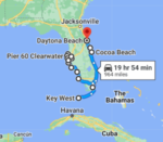
Tennessee to anywhere
AAA June 2026 · One way · Hover any state
Total: ~4,113 miles · ~67 hours · Passport required · Route through 4 Canadian provinces/territories · Estimated gas cost ~$1,000 one way
How We Calculate Gas Cost From Tennessee To Every State
The rules behind every number you’ll see:
- Vehicle: 20 MPG — a fair average for most cars and SUVs (set your own with the MPG box on the map)
- Routes: Real driving routes out of Murfreesboro, not straight-line distance
- Destination: The geographic center city of each state
- Gas prices: Each state’s own AAA average — not a national blend
- Data source: AAA Gas Prices, June 2026
- Direction: One way from Murfreesboro, Tennessee
So a drive to Georgia uses Georgia’s gas price for the Georgia miles — not Tennessee’s price stretched across the whole trip. That’s what sets this apart from a one-number calculator.
Cheapest And Most Expensive Drives From Tennessee
- Kentucky is the cheapest drive at $32 one way — 173 miles and about three hours, practically a neighbor.
- Washington is the most expensive at $483 — and here’s the twist: it edges out California ($458) even though California has pricier gas. The long northern route to Washington racks up more miles through its own $5.53 gas, so it wins the “priciest” title outright.
- Texas is the best value for the distance: $166 for 919 miles, riding cheap southern gas almost the whole way.
- A southern-crossroads bargain: twelve states come in under $100 one way — and they fan out in every direction, from Kentucky, Alabama, Georgia, and the Carolinas to the whole Ohio Valley. Few starting points reach this many states this cheaply.
- Florida is the classic sweet spot at $124 — about 10 hours and 654 miles, the long-but-doable run to Orlando.
How Long Does It Take To Drive From Tennessee To Every State?
Cost is one half of the trip; hours in the seat are the other. We mapped the drive time too — a quick 3h15m hop to Kentucky on the near end, stretching all the way out to 34 hours to reach the Pacific Northwest.
Tennessee to anywhere
AAA June 2026 · One way · Hover any state
Total: ~4,113 miles · ~67 hours · Passport required · Route through 4 Canadian provinces/territories · Estimated gas cost ~$1,000 one way
Gas Cost And Drive Time From Tennessee To Every State
Sorted by cost, lowest to highest. All figures one way from Murfreesboro, Tennessee, at 20 MPG.
| State | Gas Cost | Drive Time | Miles | Gas Price There |
|---|---|---|---|---|
| Kentucky | $32 | 3h 15m | 173 mi | $3.65 |
| Alabama | $43 | 4h | 235 mi | $3.70 |
| Georgia | $56 | 5h 25m | 300 mi | $3.77 |
| Indiana | $57 | 4h 55m | 322 mi | $3.36 |
| Mississippi | $57 | 5h 40m | 310 mi | $3.68 |
| Arkansas | $76 | 6h 15m | 416 mi | $3.70 |
| South Carolina | $80 | 6h 25m | 430 mi | $3.70 |
| North Carolina | $87 | 7h 10m | 476 mi | $3.71 |
| Virginia | $89 | 7h | 480 mi | $3.83 |
| Illinois | $91 | 7h 30m | 456 mi | $4.40 |
| Ohio | $91 | 7h | 476 mi | $4.09 |
| West Virginia | $91 | 7h 10m | 486 mi | $4.04 |
| Michigan | $102 | 8h 25m | 570 mi | $4.20 |
| Missouri | $104 | 8h 25m | 528 mi | $3.76 |
| Louisiana | $106 | 9h 35m | 579 mi | $3.67 |
| Florida | $124 | 10h 15m | 654 mi | $3.86 |
| Oklahoma | $126 | 9h 50m | 692 mi | $3.58 |
| Maryland | $127 | 10h 10m | 676 mi | $3.85 |
| Pennsylvania | $137 | 10h 25m | 720 mi | $4.23 |
| Iowa | $138 | 11h 40m | 713 mi | $3.73 |
| Delaware | $144 | 11h 35m | 765 mi | $3.82 |
| Kansas | $147 | 11h 40m | 759 mi | $3.74 |
| Wisconsin | $147 | 11h 15m | 788 mi | $3.89 |
| New Jersey | $163 | 12h 45m | 856 mi | $4.13 |
| Texas | $166 | 13h 25m | 919 mi | $3.54 |
| Nebraska | $186 | 15h 5m | 958 mi | $3.91 |
| Connecticut | $193 | 14h 55m | 987 mi | $4.24 |
| Minnesota | $195 | 15h 40m | 1,036 mi | $3.88 |
| New York | $196 | 14h 10m | 967 mi | $4.38 |
| Rhode Island | $207 | 15h 35m | 1,050 mi | $4.08 |
| Massachusetts | $209 | 16h 30m | 1,062 mi | $4.20 |
| New Mexico | $225 | 17h 45m | 1,226 mi | $3.94 |
| South Dakota | $227 | 17h 15m | 1,168 mi | $3.98 |
| New Hampshire | $235 | 18h | 1,186 mi | $4.17 |
| Vermont | $237 | 17h 35m | 1,155 mi | $4.32 |
| Colorado | $240 | 19h | 1,238 mi | $4.13 |
| North Dakota | $243 | 19h 25m | 1,283 mi | $3.86 |
| Maine | $263 | 20h 15m | 1,324 mi | $4.17 |
| Wyoming | $266 | 20h 35m | 1,354 mi | $4.23 |
| Arizona | $317 | 24h | 1,661 mi | $4.44 |
| Utah | $324 | 25h | 1,635 mi | $4.31 |
| Montana | $344 | 26h | 1,728 mi | $4.25 |
| Idaho | $382 | 28h | 1,884 mi | $4.43 |
| Nevada | $423 | 30h | 2,045 mi | $4.93 |
| California | $458 | 31h | 2,177 mi | $5.76 |
| Oregon | $475 | 34h | 2,273 mi | $5.01 |
| Washington | $483 | 34h | 2,316 mi | $5.53 |
| Alaska ⚠️ | ~$1,000 | ~67h | ~4,113 mi | varies* |
*Alaska gas price varies by Canadian province; estimate uses a blended rate. All figures one way from Murfreesboro, TN, at 20 MPG. AAA averages, June 2026.
Times are no traffic, direct route, rounded to the nearest 5 minutes. Real world drive time will vary — budget extra for stops, construction, and the inevitable “we need snacks” moment 40 miles before the exit. 😄
Can You Drive From Tennessee To Alaska?
Yes, you can actually drive from Tennessee to Alaska. But let’s be real — this is a completely different kind of trip.
- Total miles: approximately 4,113 one way
- Drive time: roughly 67 hours
- Passport required: you drive through 4 Canadian provinces
- Route: Tennessee → Kentucky → Illinois → Wisconsin → Minnesota → North Dakota → Saskatchewan → Alberta → British Columbia → Yukon → Alaska
- Estimated gas cost: approximately $1,000 one way
British Columbia is typically the most expensive leg of the Canadian portion, and the sheer distance is what drives the total up. The Canadian provinces are surprisingly reasonable on their own — it’s just a LOT of road.
Worth knowing: some states issue Enhanced Driver’s Licenses that allow land border crossings into Canada without a full passport. Check with your state’s DMV before you go.
Frequently Asked Questions
Because gas actually costs different amounts in different states. California and Washington run over $5.50 a gallon. Texas, Oklahoma, and Tennessee often sit under $3.65. If we used Tennessee’s price for the entire trip, you’d get a completely wrong number for anything far from home. We use the actual price in each state for the miles you drive there.
Using the geographic center of each state gives everyone a fair, consistent target. If we picked major cities, some states would look artificially cheap or expensive just because their biggest city happens to sit near a border. The center point puts every state on equal footing.
No — all numbers are one way. Double it for a rough round trip estimate, though your return cost may vary a little depending on gas prices when you travel.
Use the MPG box above the map — type your number and every cost updates instantly.
Gas prices are based on AAA state averages from June 2026. Gas prices change constantly — for the most current numbers before your trip, check aaa.com/gas.
Ready To Start Planning?
Now that you know what gas will cost, the fun part is picking a direction. Check out our Tennessee road trip guides for ideas on where to stop and what to see — whether you’re staying close with the Smokies and the Nashville-to-Memphis run or pointing the car somewhere far off.
Hi, I’m Alice. I’ve been running Road Trip Owl for five years and taking 6+ multi-day road trips a year (plus more weekend escapes than I can count). These maps come from the real road — real routes, real prices, no national averages.