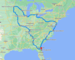


Kentucky sits right in the heart of the eastern half of the country, and the cheap end of this map proves it. From Lebanon, a run to Indiana is about $31 one way, Tennessee just $32, and thirteen states come in under $100 total. The far end is a near-tie: Oregon, Washington, and California all land within $4 of each other, topping out around $481. Everything in between comes down to distance and what gas costs in each state you cross.
We built an interactive map that lays out every state’s number at once.
What sets it apart from a normal gas calculator: instead of one national average, it charges each state’s real gas price for the miles you actually drive there. Kentucky’s cheap gas only counts for the Kentucky miles; pricey Oregon gas only counts once you’re in Oregon. There’s also an MPG box on the map — type your car’s real number and every figure updates instantly.
Kentucky to anywhere
AAA June 2026 · One way · Hover any state
Total: ~3,970 miles · ~65 hours · Passport required · Route through 4 Canadian provinces/territories · Estimated gas cost ~$960 one way
How We Calculate Gas Cost From Kentucky To Every State
The rules behind every number you’ll see:
- Vehicle: 20 MPG — a fair average for most cars and SUVs (set your own with the MPG box on the map)
- Routes: Real driving routes out of Lebanon, not straight-line distance
- Destination: The geographic center city of each state
- Gas prices: Each state’s own AAA average — not a national blend
- Data source: AAA Gas Prices, June 2026
- Direction: One way from Lebanon, Kentucky
So a drive to Tennessee uses Tennessee’s gas price for the Tennessee miles — not Kentucky’s price stretched across the whole trip. That’s what sets this apart from a one-number calculator.
Cheapest And Most Expensive Drives From Kentucky
- Indiana is the cheapest drive at $31 one way — just 180 miles and about three hours, practically a commute.
- Oregon is the most expensive at $481 — but it’s a photo finish: Washington ($478) and California ($477) are right on its bumper. All three Pacific states cost essentially the same from here, even though they sit at different distances with different gas prices.
- Texas is the best value for the distance: $191 for 1,058 miles, riding cheap southern gas most of the way.
- A wide cheap zone: thirteen states come in under $100 one way, fanning out in every direction — Indiana, Tennessee, Ohio, the Carolinas, even Arkansas at the edge. Kentucky’s central spot does a lot of the work.
- Florida is the classic sweet spot at $146 — about 12 hours and 777 miles, the long-but-easy run to Orlando.
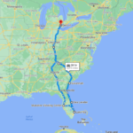
How Long Does It Take To Drive From Kentucky To Every State?
Cost is one half of the trip; hours in the seat are the other. We mapped the drive time too — a quick 3h15m hop to Indiana or Tennessee on the near end, all the way out to 35 hours to reach the Pacific Northwest.
Kentucky to anywhere
AAA June 2026 · One way · Hover any state
Total: ~3,970 miles · ~65 hours · Passport required · Route through 4 Canadian provinces/territories · Estimated gas cost ~$960 one way
Gas Cost And Drive Time From Kentucky To Every State
Sorted by cost, lowest to highest. All figures one way from Lebanon, Kentucky, at 20 MPG.
| State | Gas Cost | Drive Time | Miles | Gas Price There |
|---|---|---|---|---|
| Indiana | $31 | 3h 15m | 180 mi | $3.36 |
| Tennessee | $32 | 3h 15m | 173 mi | $3.64 |
| West Virginia | $58 | 4h 50m | 303 mi | $4.04 |
| Ohio | $62 | 5h 25m | 316 mi | $4.09 |
| Alabama | $72 | 6h 30m | 395 mi | $3.70 |
| Illinois | $73 | 6h 10m | 388 mi | $4.40 |
| Michigan | $77 | 6h 45m | 429 mi | $4.20 |
| Georgia | $78 | 7h 10m | 422 mi | $3.77 |
| South Carolina | $81 | 7h 10m | 441 mi | $3.70 |
| Virginia | $81 | 6h 45m | 420 mi | $3.83 |
| North Carolina | $87 | 7h 35m | 476 mi | $3.71 |
| Mississippi | $95 | 8h 10m | 519 mi | $3.68 |
| Arkansas | $99 | 8h 35m | 539 mi | $3.70 |
| Maryland | $111 | 9h 25m | 574 mi | $3.85 |
| Missouri | $113 | 8h 55m | 581 mi | $3.76 |
| Pennsylvania | $118 | 9h 30m | 603 mi | $4.23 |
| Wisconsin | $121 | 10h 10m | 648 mi | $3.89 |
| Iowa | $128 | 10h 20m | 669 mi | $3.73 |
| Louisiana | $131 | 11h 50m | 718 mi | $3.67 |
| Delaware | $132 | 10h 55m | 682 mi | $3.82 |
| Oklahoma | $137 | 11h 25m | 745 mi | $3.58 |
| Kansas | $142 | 11h 35m | 751 mi | $3.74 |
| Florida | $146 | 12h 15m | 777 mi | $3.86 |
| New Jersey | $152 | 11h 55m | 758 mi | $4.13 |
| New York | $167 | 12h 45m | 808 mi | $4.38 |
| Minnesota | $182 | 14h 10m | 935 mi | $3.88 |
| Connecticut | $186 | 14h | 907 mi | $4.24 |
| Rhode Island | $188 | 14h 55m | 933 mi | $4.08 |
| Massachusetts | $190 | 15h | 945 mi | $4.20 |
| Nebraska | $190 | 15h 20m | 990 mi | $3.91 |
| Texas | $191 | 16h | 1,058 mi | $3.54 |
| Vermont | $207 | 16h 5m | 994 mi | $4.32 |
| New Hampshire | $217 | 16h 15m | 1,043 mi | $4.17 |
| North Dakota | $220 | 18h | 1,155 mi | $3.86 |
| South Dakota | $221 | 17h 15m | 1,144 mi | $3.98 |
| Colorado | $236 | 19h 5m | 1,227 mi | $4.13 |
| New Mexico | $242 | 19h 45m | 1,310 mi | $3.94 |
| Maine | $245 | 19h 10m | 1,205 mi | $4.17 |
| Wyoming | $272 | 21h 20m | 1,394 mi | $4.23 |
| Montana | $318 | 25h | 1,635 mi | $4.25 |
| Utah | $320 | 24h | 1,627 mi | $4.31 |
| Arizona | $335 | 26h | 1,752 mi | $4.44 |
| Idaho | $376 | 29h | 1,874 mi | $4.43 |
| Nevada | $429 | 31h | 2,085 mi | $4.93 |
| California | $477 | 34h | 2,269 mi | $5.76 |
| Washington | $478 | 34h | 2,325 mi | $5.53 |
| Oregon | $481 | 35h | 2,313 mi | $5.01 |
| Alaska ⚠️ | ~$960 | ~65h | ~3,970 mi | varies* |
*Alaska gas price varies by Canadian province; estimate uses a blended rate. All figures one way from Lebanon, KY, at 20 MPG. AAA averages, June 2026.
Times are no traffic, direct route, rounded to the nearest 5 minutes. Real world drive time will vary — budget extra for stops, construction, and the inevitable “we need snacks” moment 40 miles before the exit. 😄
Can You Drive From Kentucky To Alaska?
Yes, you can actually drive from Kentucky to Alaska. But let’s be real — this is a completely different kind of trip.
- Total miles: approximately 3,970 one way
- Drive time: roughly 65 hours
- Passport required: you drive through 4 Canadian provinces
- Route: Kentucky → Indiana → Illinois → Wisconsin → Minnesota → North Dakota → Saskatchewan → Alberta → British Columbia → Yukon → Alaska
- Estimated gas cost: approximately $960 one way
British Columbia is typically the most expensive leg of the Canadian portion, and the sheer distance is what drives the total up. The Canadian provinces are surprisingly reasonable on their own — it’s just a LOT of road.
Worth knowing: some states issue Enhanced Driver’s Licenses that allow land border crossings into Canada without a full passport. Check with your state’s DMV before you go.
Frequently Asked Questions
Because gas actually costs different amounts in different states. California and Washington run over $5.50 a gallon. Texas, Oklahoma, and Tennessee often sit under $3.65. If we used Kentucky’s price for the entire trip, you’d get a completely wrong number for anything far from home. We use the actual price in each state for the miles you drive there.
Using the geographic center of each state gives everyone a fair, consistent target. If we picked major cities, some states would look artificially cheap or expensive just because their biggest city happens to sit near a border. The center point puts every state on equal footing.
No — all numbers are one way. Double it for a rough round trip estimate, though your return cost may vary a little depending on gas prices when you travel.
Use the MPG box above the map — type your number and every cost updates instantly.
Gas prices are based on AAA state averages from June 2026. Gas prices change constantly — for the most current numbers before your trip, check aaa.com/gas.
Ready To Start Planning?
Now that you know what gas will cost, the fun part is picking a direction. Check out our Kentucky road trip guides for ideas on where to stop and what to see — whether you’re staying close with the Bourbon Trail and Red River Gorge or pointing the car somewhere far off.
Hi, I’m Alice. I’ve been running Road Trip Owl for five years and taking 6+ multi-day road trips a year (plus more weekend escapes than I can count). These maps come from the real road — real routes, real prices, no national averages.